Tuesday 19 July 2016

France 2016 Day 8 - The Pyrenees - Hautacam and Col du Soulor

We were staying in Argeles Gazost - by choice at it is at the end of a valley that sees Hautacam, Soulor, Luz Ardidenne and Tourmalet all reached directly.

On the first day on the area I climbed Hautacam. Unfortunately in the morning the cloud was low and although it was dry but grey at the valley floor I soon found that about 200m higher it was full-on cloud, so much so that at times visibility was less than 100m or so. The cloud also meant that I could not decide whether it was "warm" or "cold". For the first time in France I had looked at the weather and put on my gilet and arm warmers. At times it was cold enough for this full on gear, at others I had the arms rolled down and the gilet open and flapping. I was pretty wet after 20 minutes or sp of climbing and it was a 50-50 mix of sweat and cloud.

I ran my Garmin Virb for the climb - see here:


However after 10 minutes or so the lens just got covered in moisture and I have a climb of vague grey blurry shapes - hence the highly shortened video

An upside of the gloom was that I could not actually see where I needed to  climb to and so was in happy ignorance. In reality it was unhappy ignorance as it was a beast of a climb. There was a point perhaps 3-4km from the summit when you cross a cattle grid and the trees start to disappear. The gradient also eases a bit and this signifies that you really are near the top. A little further on the cloud started to lift (or as I found out I climbed above the cloud) and the sun came up.

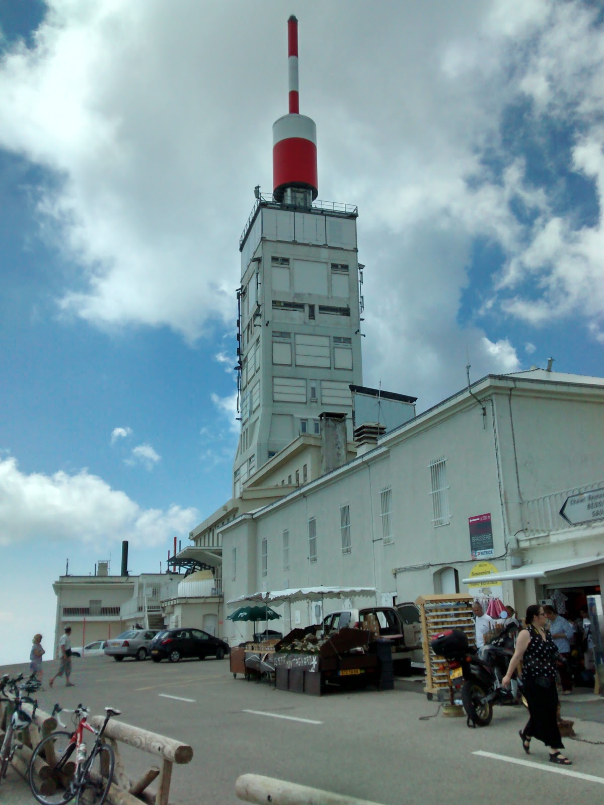
After a few more hairpins you "seem" to be at the top. I say seem as in reality the top of Hautacam is just a big car park. With a bit of searching you can see some painting on the road marking a previous Tour de France finish. I didn't realise this at the time and carried on up the road. This was a series of switchbacks for about 1.5km and another 150m or so to climb to another smaller car park with a small cafe (closed) and an observatory. This is the summit of the Col de Tramassel. That is the actual top. Its a col that goes nowhere - the only way from the top by road is the way that you came up unless you use a mountain bike.

I stopped to take some photos:


After the short photography session I set off back down the road. Needless to say the first few km were still above the cloud and in the sun but the vast majority of the descent was in the same overcast and wet cloud. Visibility of 100m is significantly worse at 30mph than 5mph so it was a very slow and tentative descent indeed. Cold enough as well that I needed the jersey, arm warmers and gilet of the ascent but I needed my Pocket Rocket waterproof on as well!. It was just about warm enough by the time I got back to the campsite and an hour later was blazing sunshine!

I'd climbed my first Pyrenean Col but saw virtually nothing of it except the very summit.

Here's the Strava data:


You can see that the damp got in the Garmin pressure port and screwed up the barometric elevation

Basic data: 1hr 11min, 7.9miles at average gradient of 8% - 3362feet

The weather forecast was not at all great for the rest of the week so with the good weather from lunchtime I decided to climb Col Du Soulor.

The start of this climb is hidden round the back of the town of Argeles Gazost and sign posted for Col d'Aubisque. I had a half thought that as this 2nd col was about 7-8km further from Soulor I might do that as well. However I soon scotched that idea within the first 4-5km of the climb as the temperature difference could not be more different from the morning. The heat was high and immediately the climb difficult (for me).

Its an odd climb - 4-5 km of typical 6-8% followed by 4-5km or almost flat followed by another 5-6km of 7-9% climb. To be honest I struggled most of the way and was glad to get to the top. There was actually a couple of cafes at the top but I don't stop for anything other than a few photos and came back down again.


A good descent with a good road surface, sweeping bends and long straights.


All told for the day over 7000ft of ascent.

Thursday 14 July 2016

France 2016 Day 6 - Provence - Mont Ventoux


The Mighty "Giant of Provence" - Mont Ventoux. I had been lucky enough to persuade my wife (or perhaps lucky that she agreed!) to come on a cycling holiday with me (a cycling holiday for me - not for her!). We'd spent a week in the French Alps and were travelling to the Pyrenees. However Provence is on the way and we stopped in Bedoin so I could cycle the iconic Mont Ventoux.

All the words are true - as we approached in the car the giant mountain loomed ahead with nothing around it - it was huge and quite daunting in some respects. We parked in the town centre of Bedoin (for free as is nearly always the case in France). I got the bike out of the car, put the wheels back on and got changed in the clean public toilet and set off.

It was a really hot day and I'd not got going until 1pm. It was a nice start for less than a km through the town but then straight out into the open countryside and baking sun with temperatures over 30Deg C. For some reason (perhaps the heat) my heart rate was very high right from the start and I felt I had to slow down to pace myself over the whole climb. Before the climb proper (although the gradient was a few %) the road had been recently re-surfaced and I was accompanied by the sticky sound of tyres covered in tarmac sucking themselves onto the road. I took several km for this to wear off.

The climb proper started immediately after a left hand hairpin bend. It kicked up to 7-8% and in reality the climb stayed at this and then increased to between 8-10% for the next 12km up to the cafe at Chalet Reynard.

This first section to the cafe was very difficult. The heat was high and whilst there was shade from the scrubby trees this offered no relief. The km markers appeared regularly but a long way apart as I was managing only 6mph or so, but at least I could see progress being made.

There seemed to be no relenting in the gradient and it was a matter of making sure I managed my pace and kept hydrated properly with small but frequent sips of water. I was passed by 1 or 2 other cyclists and think I passed a couple of others in this stretch but it was slow and lonely progress.

I had hoped to switch between the 28 and 32 gear on the rear but right from the first corner I was in the 32 so I had no where else to go. I find that even if the 28 was a little too high changing up to it with the resultant cadence change for a few 100m was a good rest and gave further relief when I dropped back to the 32. For Ventoux I just had to grind up on the 32 all the way.

Finally Chalet Reynard appeared after about 90minutes and 12km of climbing and the relief was significant. The gradient eased for several hundred meters in front of the cafe and I got a real rest from this.
 
Chalet Reynard
Passing the cafe I also sensed a bit of a tail wind and as I approached the next section of the climb I was riding easily in the 28 and started the climb "strongly" in that gear. This 2nd phase of the climb is at a slightly lower gradient (more 6-7% than 8-10%) and I felt good and also that the climb was relatively speaking over and that the hard part was done.

This section was completely tree less and thus without shade but the breeze (no more than this really) also made the conditions a lot more comfortable. I passed a few other people on this stretch and was able to spend about 50% of the time in the 28 and the rest in the 32. I had a gel and a cereal bar and felt reasonably good.

About 1.2km from the summit I could see the Tom Simpson memorial and swung out across the road to get a better view on my Virb:

The Tom Simpson Memorial

I'd expected to see the traditional water bottles at the food but it was quite clean. I guess its periodically cleared up.
 
The gradient for the last km however rose and the last km was probably nearer 10% average compared to the previous 4or 5 km at a lower 6-7%. The fact that you could see the summit so close was both heartening and disheartening at the same time and it meant that the progress seemed really slow.


The "Top" - 1km to go
However, finally you reach the last hairpin just meters from the summit:


The Final Hairpin
Rounding this the summit is just 100m or so way:


I took the requisite pictures of the summit sign (and with me):


Here's an artistic picture of my bike looking over the summit to the east:


Here's the building at the top (an observatory I think):


And here's my bike with the sign:


It was everything I hoped and expected and the sense of achievement was enormous. It was certainly one of the hardest climbs I have done

Here's a video of the last 6-7miles of ascent:


Link to Strava Ride: https://www.strava.com/activities/626638731

Stats - The Strava HC Category climb from Bedoin to the summit: 12.4 miles, 5050ft of ascent at an average of 8%.

I managed 1:57:30 - an average speed of 6.4mph. (Compared to KoM Laurens ten Dam who  climbed in 58:26 - an average speed of 12.8mph). My time put me 15836 out of 30521 so just below the 50% mark - I was very pleased with this.


I am not really a keen descender but the wide road and long gradients meant I could really put the hammer down. It was tremendous fun

Here's a video of 10 miles of descent towards Bedoin: