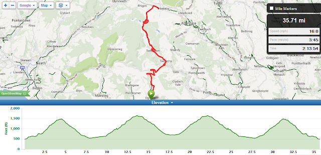
I went to collect one of our sons from Exeter University on 22 Dec, and had suggested that we cycled before returning - in particular I wanted to ride up Haytor. He was OK with this so I put my bike in the car and drove down. I still wasn't sure whether the weather would be ok given the forecast but it was good enough in Exeter at about 11 so we decided to take the risk, although accepting that higher on Dartmoor might be a bit different. We set off and ended up riding on a route that we'd done when I took his bike down in October 2012.
I'd liked to have ridden somewhere different but the advantage of re-riding a route for only the second time is that you are guaranteed lots of achievements. The route heads out of Exeter to Longdown which is a long undulating Strava Cat 4 drag up followed by a fast descent at the bottom of Longdown we joined the 2013 Tour of Britain route and followed this to the top of Haytor.
The next climb was 6 Mile Hill (which isn't 6 miles and the longest Strava segment comes in at 3.6 miles) - compared to Longdown this is a tougher climb, a Strava Cat 3, as it is a more continuous climb. After 6 Mile Hill there's a descent and short climb into Mortonhampstead, and then a 7 mile run, generally down hill, to Bovey Tracey.
At the roundabout you can either turn left into Bovey Tracey itself or right straight into the climb to Haytor, which is what we did. From the roundabout its then uphill for over 3.5 miles to the top of Haytor. After 1/2 a mile from the roundabout there was a left fork and then the road continues on and up. At this point it also started raining reasonably steadily and the wind got up. It had been fairly breezy on the way over but for the next 2 miles or so the wind was very strong and the rain was heavy.
The Haytor climb was relentless. I tried to keep in 2nd (34-25) for as long as possible to save something for the end but I had to use the 34-28 on numerous occasions given the wind. My son was very gradually pulling away from me but I was never losing sight of him. It was tough to the cattle grid, and for a while after, but I soon realised that the trees that lined the road were doing a very good job of sheltering me from the wind, as after another 5 minutes or so the trees cleared and we were on the side of the hill. The wind seemed stronger than ever, and although there was intermittent shelter from the gradient itself it was strong. At about 2 1/2 miles it levelled out a little as we rode past the visitor centre, and although it had stopped raining by then there was no shelter from the wind and it then got steeper again for the final mile or so to the summit. This last bit was incredibly tough, especially as the top was almost in sight. I struggled up and rejoined my son. I was probably about 60 seconds behind him which I was reasonably happy with.
Looking at Strava later, Haytor is a Strava Cat 2. This is therefore the toughest hill I have ever climbed and it certainly felt it. It took me over 27 minutes from the roundabout at the bottom to the top. This placed me about 550th of 1050 riders. My general aim to be in the top 1/3rd wasn't met but given the conditions I was just about OK with this. I feel there is probably a couple of minutes I could pull out of the time given better conditions in the summer but I am not going to trouble the leader boards on a climb this long.
We then rode back down (I realised how long the climb was as we seemed to descend forever even at nearly 40 mph for periods). We stopped briefly in Bovey Tracey at Tesco for some chocolate and the rode back - but given Exeter it wasn't an easy return. We rode along the Teign Valley back to the bottom of the other side of Longdown - although it followed the river it was clear the river was losing a lot of height as its a long drag, and then Longdown is another Cat 4 climb back, and then there's the short sharp Poccombe Hill just on the re-entry to Exeter itself
I was glad to be back, but I am pleased to say, so was my son!
It was 45.6 miles, and 4285ft of climbing, so a very challenging ride - almost the magic 100ft/mile of ascent. 44 Strava achievements were a good reward as well.
Apart from the rain climbing Haytor we were lucky with the weather so for a winter ride a few days before Christmas we were very fortunate. Well worth doing.
Monday, 23 December 2013
Team JLR - STRAVA - Part 2
When I went to get one of our sons from Exeter University I took my bike done and we rode to Haytor (See here)
The distance of this ride together with the rides on Friday and Saturday pushed me to 2nd position for total distance and climbing in the Team JLR Strava club and I was also second in individual ride distance until Gavin Oag snuck in a better ride. So two 2nd places and a 3rd in a single week is another good achievement:
The distance of this ride together with the rides on Friday and Saturday pushed me to 2nd position for total distance and climbing in the Team JLR Strava club and I was also second in individual ride distance until Gavin Oag snuck in a better ride. So two 2nd places and a 3rd in a single week is another good achievement:
 |
| Week Ending 22 Dec 2013 |
Sunday, 15 December 2013
The Number 11 Bus Route
According to Wikipedia The Number 11 Bus Route is "Europe's second longest urban bus route". Part of the route runs past Sarehole Mill which is less than 2 miles from my house. I'd been thinking about the practicalities of riding the route for some time and plotted out the 'A' (anticlockwise) route in Garmin Connect based on the info on the bus company's web site, assuming a start and finish at Sarehole Mill. I was reasonably comfortable that I knew about 60-70% of the route and that part was OK. The other 30% I was less sure about. This part started from Erdington Five Ways and ran through Aston, Witton and Winson Green (past the prison) before joining the Hagley Road where I knew the route again. There looked like a few busy roads so I decided that for this reason, and more generally for traffic that this route would be an early Sunday morning ride only. This Sunday I felt pretty tired and not really up for a long ride so decided to give it a go. The roads were quite wet so I decided to take the Giant (with mudguards) rather than the Scott.
After a short ride to Sarehole Mill off I started on the route. On the whole it was reasonably easy to follow - the Garmin seemed to behave itself on the whole. It got mildly confused somewhere between Erdington and Aston, but fortunately a number 11A bus appeared and I was able to follow it for 100yards or so.
At 9am in the morning the roads were pretty quiet all round. There were some gentle 'climbs' but I was able to keep in the big ring all the way. It took about 1hr 40 minutes for the 25 miles or so. There were a few traffic lights but on the whole it was a pretty even ride round. It would take a lot longer on a weekday or not as early and some of the roads and junctions would be fairly cyclist unfriendly with more traffic.
I had also plotted the 11C (clockwise) route as well and had thought of riding both in the same day but felt too tired to go back round for another 25 miles or so this time.
Here's the Strava Ride:
And to my shame I made a segment for it as well:
Needless to say its a KOM, although when I created the segment it did identify 2 similar segments - both of these were on quite a lot of the route but neither followed it fully or all the way round, so I don't feel too bad.
Would I do it again? Probably once more, and I'll do the 11C route as well to get the set. I am surprised no one else has ridden it to be honest, although it is not the most scenic route by a long way.
Monday, 9 December 2013
Team JLR - STRAVA
One of our colleagues created a Strava Club for JLR PD employees recently. As its all about the bragging rights I joined - as there are some pretty strong cyclist at JLR I never expected to get much recognition.
Recently however I was 2nd highest climber for the week and by a fraction of a mile rode the furthest this week - I won't get many of these so out with the trumpet and a self blown fanfare and upload the images for recording this feat for posterity:
Recently however I was 2nd highest climber for the week and by a fraction of a mile rode the furthest this week - I won't get many of these so out with the trumpet and a self blown fanfare and upload the images for recording this feat for posterity:
 |
| Second Best Climber (w/e 24-Nov-2013) |
 |
| Longest Rider (w/e 8-Dec-2013) |
Saturday, 7 December 2013
Clent Again - and a Coffee Stop
I went to Clent again recently, this time with Noel for the first time for 5 months or so. Based on the previous ride I planned the same but added another climb.
The new climb was from the A456 "Hagley Causeway" road up Hagley Wood Lane to the Nimmings Car Park and Cafe at the Clent Hills Visitor Centre. This was a tough climb. I went on the Scott and feel it would have been very tough on the Giant in its current "Winter" mode.
We stopped for a coffee at the cafe and then came back. I think there's one more climb to the Clent Hills, up Uffmoor Lane, so I'll go over again to do that one and then I feel Clent is out of my system for a while
Winter Riding = Dirty Riding
I am a pretty well year round rider, but there's one thing about riding in the winter that is a pain and that's the filth from the road. Here's my Scott after 40 miles of the roads between Solihull, Meriden and Bedworth:


I don't think I am overly precious about my bikes but I do tend to try to keep them clean. After this ride I cleaned the Scott properly and assumed that it would not be ridden again until Spring. However a few weekends later the roads were dry and the lure of the Scott was just too great. Its not as dirty this time but its certainly not clean like it was...
The worst thing is the wheel rims that tend to get machined away if the roads are too wet or mucky. I am still using the RS80s on the Scott and these really seem to get eaten by the muck. On the Giant I refit the original heavy Giant wheels in the winter for this reason alone - these wheels are in the £80 region to replace rather than the £350 region for the RS80s. But in the end the bikes are there to be ridden. So I do.
Tuesday, 26 November 2013
A Ride to Clent - 24 November 2013
This Sunday I rode over to the Clent Hills and Clent. In particular I wanted to go to St Kenelms Pass - given the mythical name (and it being a Strava Cat 4 Climb) I felt it might be worth the effort. I have known that the Clent Hills are relatively close but was never sure exactly where they were - by this I mean what roads are worth using to climb and what are just boring roads and what are downright dangerous. To help in this however one of my followers (and I follow as well), Neal Lamont, had posted just such a ride on Strava in September this year that I could use as a template - the link is here: Saturday Ride and here is a screenshot:
 This was actually a much longer ride than I wanted to do (a maximum of about 40 was what I was looking for) so I could keep it to around 2.5-3 hours in duration, but Neal had done a load of riding in Alvehcurch that added quite a lot of distance, so I felt if I cut all that out and rode direct to Catshill I could make it more suited to what I wanted to do.
I used Garmin Connect to create a route:
 This route meant I rode over to Rose Hill and onto Catshill. This is part of a route I have done quite a few times in the past. What was new was continuing on to Belbroughton and then on to St Kenelms Pass and Clent where I added some loops.
As you can see from the image above the climbs started at about 18 miles. In fact St Kenelms Pass was a long but steady climb which suited me well, apart from a very short steep bit right at the end. It was quite scenic even in the cold grey winter morning and would be great in the summer. I followed the Garmin over the route above, which I created with quite a few loops back on itself to try to get all the climbs in the area in. All was well until the Garmin said turn left on to what was at best a farm track - clearly it did not go where I expected so I turned around to the last junction. The Garmin seemed happy enough but I was on a stretch of road I'd been along not long before, so at that point I decided to abort the route, ride up to the top of St Kenelms Pass from Chapel Lane again and then ride down and exactly retrace the route I'd used to come over.
The other reason for deciding on this approach was that it was actually a lot hillier than I'd expected, and with the cold weather, and my Giant in full Winter mode I was felling pretty tired. Finally given that I had another ascent of Rose Hill to do on the way back I decided discretion was the better part of valour and needed to head back.
It was the right decision because the ride home was a real drag and I was pretty shot before I even got to Rose Hill. I ground up Rose Hill at a steady but slow pace. The direct (as the crow flies) route from Rose Hill to Solihull (through West Heath, Kings Norton etc) is also extremely rolling, and I was finally glad to drag myself home.
After a shower and some calorie intake I uploaded the ride to Strava. It came out at 45.9 miles which I was OK with but what surprised me was over 4300ft of climbing and explained why I felt so tired. That seemed a really big number so I used Veloviewer which allows you to sort all your rides by a huge variety of criteria:

This shows that the ride came out as the ride with the 6th most ascent of all I have done (496 to date), the most ascent on the Giant and not far short of the same climbing as some of the 100 mile rides I have ridden, so I was decidedly happy with the achievement. I was also surprised at how much climbing I could geton a "local" route and without driving to start a ride somewhere more naturally assumed to be hilly. I'll definitely do the ride, or a variant, again - it was scenic and challenging and somewhere I have not been before. I went for a walk a few months ago with my wife to the Clent Hills and we parked by the National Trust visitor centre. When we left we went down a very long climb and I think its worth adding this to the route - however that climb will have to be a "down and up" as there was only dual carriageway at the bottom - decidedly unpleasant on a bike.
Again I am not sure why the Garmin got confused. Whether in this case its associated with planning to use the same bit of road several times I am not sure, but its something I need to get to grips with as I am keen to continue venturing further afield and need to rely on the Garmin to do this. I'll probably have to plot out local rides to follow that I know I can just experiment on without getting lost. On the way over to Rose Hill within the first few miles it threw a wobbly in Kings Norton, insisting I was off route and seemingly wanting to navigate back to the start. It appears if you go off route near the start it will give and navigate you back to the start as I found in Suffolk. Its a great device but not without its foibles.

I used Garmin Connect to create a route:

As you can see from the image above the climbs started at about 18 miles. In fact St Kenelms Pass was a long but steady climb which suited me well, apart from a very short steep bit right at the end. It was quite scenic even in the cold grey winter morning and would be great in the summer. I followed the Garmin over the route above, which I created with quite a few loops back on itself to try to get all the climbs in the area in. All was well until the Garmin said turn left on to what was at best a farm track - clearly it did not go where I expected so I turned around to the last junction. The Garmin seemed happy enough but I was on a stretch of road I'd been along not long before, so at that point I decided to abort the route, ride up to the top of St Kenelms Pass from Chapel Lane again and then ride down and exactly retrace the route I'd used to come over.
The other reason for deciding on this approach was that it was actually a lot hillier than I'd expected, and with the cold weather, and my Giant in full Winter mode I was felling pretty tired. Finally given that I had another ascent of Rose Hill to do on the way back I decided discretion was the better part of valour and needed to head back.
It was the right decision because the ride home was a real drag and I was pretty shot before I even got to Rose Hill. I ground up Rose Hill at a steady but slow pace. The direct (as the crow flies) route from Rose Hill to Solihull (through West Heath, Kings Norton etc) is also extremely rolling, and I was finally glad to drag myself home.
After a shower and some calorie intake I uploaded the ride to Strava. It came out at 45.9 miles which I was OK with but what surprised me was over 4300ft of climbing and explained why I felt so tired. That seemed a really big number so I used Veloviewer which allows you to sort all your rides by a huge variety of criteria:

This shows that the ride came out as the ride with the 6th most ascent of all I have done (496 to date), the most ascent on the Giant and not far short of the same climbing as some of the 100 mile rides I have ridden, so I was decidedly happy with the achievement. I was also surprised at how much climbing I could geton a "local" route and without driving to start a ride somewhere more naturally assumed to be hilly. I'll definitely do the ride, or a variant, again - it was scenic and challenging and somewhere I have not been before. I went for a walk a few months ago with my wife to the Clent Hills and we parked by the National Trust visitor centre. When we left we went down a very long climb and I think its worth adding this to the route - however that climb will have to be a "down and up" as there was only dual carriageway at the bottom - decidedly unpleasant on a bike.
Again I am not sure why the Garmin got confused. Whether in this case its associated with planning to use the same bit of road several times I am not sure, but its something I need to get to grips with as I am keen to continue venturing further afield and need to rely on the Garmin to do this. I'll probably have to plot out local rides to follow that I know I can just experiment on without getting lost. On the way over to Rose Hill within the first few miles it threw a wobbly in Kings Norton, insisting I was off route and seemingly wanting to navigate back to the start. It appears if you go off route near the start it will give and navigate you back to the start as I found in Suffolk. Its a great device but not without its foibles.
Saturday, 23 November 2013
Sheffield (Again)
Sheffield November 2013
I went to Sheffield and rode the route I'd ridden in March 2012 again. Actually I went to Sheffield for a long weekend with my wife, partly for her birthday and partly to see one of our sons who is at Sheffield University.
I got agreement to spend a morning cycling and I'd wondered about doing something else route-wise but having done the route once before it meant that (a) I was pretty confidant that the roads were OK, (b) that the time was realistic and most importantly that by doing the route again I sweep up a load of Stava achievements!
Here's the route:

and here's a link as for some reason the code to "embed" the ride in a blog gives a corrupt image: http://www.strava.com/activities/94293681
It started in Low Bradfield. Plenty of parking at 9am on a Sunday and, in an improvement from 18 months ago, working public toilets - an increasingly rare sight in Britain these days.
I got the bike out of the car, put the wheels on and got changed into my cycling clothes (I already had my shorts, baselayer and jersey on from the hotel). The forecast was for sun, with a light wind but temperatures around 2-3Deg C. It was the latter I was more concerned about as on the radio it has reported that Snake Pass was closed to traffic due to ice. However given the sun I decided that baselayer, jersey and long sleeve "over jersey" would be fine on the top and for my legs a pair of bib shorts and Aldi's finest leg warmers, with 2 pairs of socks and my BBB Hardwear overshoes (I get cold feet).
Once I was ready I set the Garmin to follow the route and set of. The disadvantage of Low Bradfield is, as its name suggests, its low, and every route out is a reasonable climb. Last time I got caught out but the first climb, it being quite step and within the 1st 1/2 mile. This time I turned left by the pub and rode along Dungworth Reservoir for a mile or so to try to warm up a bit. I then returned and went back down the hill slightly to ride the full hill. However given the temperature this was not enough and I was puffing and panting again at the top. What's more I still have not really got to grips with the route following on my Garmin (after 3 years!) and because I deviated from the route at the start it wanted to return me to the end. So I had to stop and reset the route.
It's then a long undulating drag for s number of miles to join the A57 and then descend down towards Ladybower Reservoir. Last time there was road works making it single track - this year I kept the speed down as I was not sure how slippery the road might be - there were small ice patches in puddles at the side of the road up to that point in the shade where the sun had not yet reached. Its a fantastic descent and I'd like to go again in the summer when its dry. Fortunately despite being a relatively major road the traffic seems pretty light. You then skirt the reservoir and drop down into Bamford - again another quite quick stretch.
Then there's a sharp right to head back on yourself and towards Brough. Once through the village this is the second long and undulating climb onto the A623, this is a generally rolling road for a few miles and then another long and fast descent. At the bottom is a left back on yourself again towards Grindleford which marks another long climb upto the A6187. This is probably, of all the climbs on the route, the one I find the easiest - whilst it's long its a pretty steady gradient with a few places where it briefly flattens to give a respite.
Then I turned on to the A625 for a fast gentle down hill run to "Long Line" - a dead straight road with an increasing gradient to the end. It was about here that I was beginning to feel a little tired and I knew that there was a climb last year that made me get off so I was trying to conserve some energy as well.
There's then some meandering miles, with some short sharp climbs to Lodge Lane near Rivelin. This is a monster descent - as last time I spent the whole descent down riding the brakes. I saw 3-4 riders coming up and it looked an absolute beast. Its not helped by the fact that near the bottom there is a sharp left hander followed by a short straight that stops at a T Junction - the road goes from a 10-12% gradient to the next road - there's no taper or flat - it's a really nasty junction. I am pretty sure that I would not make the climb the other way as its so steep quite long and these are not my strength - I much more a long drag person.
On the descent I could look across the valley and see the climb that was my nemesis last time. This is (on Strava) "Rails Road". I got in a low gear and rode up - it was much easier this year I found. I also vaguely remembered that there was a 2nd climb after this one that I gave up on as well last year, but again managed to ride up without great difficulty this year. From here it was basically to Stannington, Hill Top, Dungworth and back to Dungworth Reservoir and Low Bradfield.
I found the ride almost as hard this time as last time. However I was about 10-15 minutes quicker than last time and on all the climbs got a PR which I was very satisfied with. I think I was quicker because I was on my very best best bike (the Scott) whereas last time I rode the Giant with its original Giant wheels. These wheels are very heavy (almost 3.5kg from memory with tyres and tubes) compared to about 2kg for the Shimano RS80 wheels. This meant I was riding a 8kg bike this year versus a 11.5kg bike previously. Also and probably more relevant, last time I rode in March with relatively few miles in the preceding months, whereas this time I had done a lot of miles up to September so was much more ride fit. Its a great route but is very challenging.
As a bonus the Village shop was opening and served a half decent cup of coffee and some cakes so an even better finish to the ride.
Compared to the recent ride in Wales it was very similar in distance and total height gained, but in Wales it was mainly 4 steady climbs whereas in Sheffield its a relentless climb and ascend for the whole distance with some very short, sharp and hard climbs on the route. I am a much stronger climber on the long steady climbs between 5-8% gradient - the steeper ones I find very hard for some reason.
Here's some pictures (not great as they're from my phone):
I went to Sheffield and rode the route I'd ridden in March 2012 again. Actually I went to Sheffield for a long weekend with my wife, partly for her birthday and partly to see one of our sons who is at Sheffield University.
I got agreement to spend a morning cycling and I'd wondered about doing something else route-wise but having done the route once before it meant that (a) I was pretty confidant that the roads were OK, (b) that the time was realistic and most importantly that by doing the route again I sweep up a load of Stava achievements!
Here's the route:

It started in Low Bradfield. Plenty of parking at 9am on a Sunday and, in an improvement from 18 months ago, working public toilets - an increasingly rare sight in Britain these days.
I got the bike out of the car, put the wheels on and got changed into my cycling clothes (I already had my shorts, baselayer and jersey on from the hotel). The forecast was for sun, with a light wind but temperatures around 2-3Deg C. It was the latter I was more concerned about as on the radio it has reported that Snake Pass was closed to traffic due to ice. However given the sun I decided that baselayer, jersey and long sleeve "over jersey" would be fine on the top and for my legs a pair of bib shorts and Aldi's finest leg warmers, with 2 pairs of socks and my BBB Hardwear overshoes (I get cold feet).
Once I was ready I set the Garmin to follow the route and set of. The disadvantage of Low Bradfield is, as its name suggests, its low, and every route out is a reasonable climb. Last time I got caught out but the first climb, it being quite step and within the 1st 1/2 mile. This time I turned left by the pub and rode along Dungworth Reservoir for a mile or so to try to warm up a bit. I then returned and went back down the hill slightly to ride the full hill. However given the temperature this was not enough and I was puffing and panting again at the top. What's more I still have not really got to grips with the route following on my Garmin (after 3 years!) and because I deviated from the route at the start it wanted to return me to the end. So I had to stop and reset the route.
It's then a long undulating drag for s number of miles to join the A57 and then descend down towards Ladybower Reservoir. Last time there was road works making it single track - this year I kept the speed down as I was not sure how slippery the road might be - there were small ice patches in puddles at the side of the road up to that point in the shade where the sun had not yet reached. Its a fantastic descent and I'd like to go again in the summer when its dry. Fortunately despite being a relatively major road the traffic seems pretty light. You then skirt the reservoir and drop down into Bamford - again another quite quick stretch.
Then there's a sharp right to head back on yourself and towards Brough. Once through the village this is the second long and undulating climb onto the A623, this is a generally rolling road for a few miles and then another long and fast descent. At the bottom is a left back on yourself again towards Grindleford which marks another long climb upto the A6187. This is probably, of all the climbs on the route, the one I find the easiest - whilst it's long its a pretty steady gradient with a few places where it briefly flattens to give a respite.
Then I turned on to the A625 for a fast gentle down hill run to "Long Line" - a dead straight road with an increasing gradient to the end. It was about here that I was beginning to feel a little tired and I knew that there was a climb last year that made me get off so I was trying to conserve some energy as well.
There's then some meandering miles, with some short sharp climbs to Lodge Lane near Rivelin. This is a monster descent - as last time I spent the whole descent down riding the brakes. I saw 3-4 riders coming up and it looked an absolute beast. Its not helped by the fact that near the bottom there is a sharp left hander followed by a short straight that stops at a T Junction - the road goes from a 10-12% gradient to the next road - there's no taper or flat - it's a really nasty junction. I am pretty sure that I would not make the climb the other way as its so steep quite long and these are not my strength - I much more a long drag person.
On the descent I could look across the valley and see the climb that was my nemesis last time. This is (on Strava) "Rails Road". I got in a low gear and rode up - it was much easier this year I found. I also vaguely remembered that there was a 2nd climb after this one that I gave up on as well last year, but again managed to ride up without great difficulty this year. From here it was basically to Stannington, Hill Top, Dungworth and back to Dungworth Reservoir and Low Bradfield.
I found the ride almost as hard this time as last time. However I was about 10-15 minutes quicker than last time and on all the climbs got a PR which I was very satisfied with. I think I was quicker because I was on my very best best bike (the Scott) whereas last time I rode the Giant with its original Giant wheels. These wheels are very heavy (almost 3.5kg from memory with tyres and tubes) compared to about 2kg for the Shimano RS80 wheels. This meant I was riding a 8kg bike this year versus a 11.5kg bike previously. Also and probably more relevant, last time I rode in March with relatively few miles in the preceding months, whereas this time I had done a lot of miles up to September so was much more ride fit. Its a great route but is very challenging.
As a bonus the Village shop was opening and served a half decent cup of coffee and some cakes so an even better finish to the ride.
Compared to the recent ride in Wales it was very similar in distance and total height gained, but in Wales it was mainly 4 steady climbs whereas in Sheffield its a relentless climb and ascend for the whole distance with some very short, sharp and hard climbs on the route. I am a much stronger climber on the long steady climbs between 5-8% gradient - the steeper ones I find very hard for some reason.
Here's some pictures (not great as they're from my phone):
 |
| My Scott after the ride in Low Bradfield |
 |
| My Scott after the ride in Low Bradfield |
 |
| The requisite selfie, me looking very red |
 |
| Low Bradfield Village Green and Cricket Pitch |
 |
| Low Bradfield Bowling Green |
 |
| Low Bradfield Village Shop and Post Office |
 |
| Low Bradfield Village Shop and Post Office |
Thursday, 31 October 2013
Cycling up some Hills in South Wales
My wife and I had a long weekend away recently. She chose Wales (near Cardiff) as a location so we stayed in Port Talbot as its half way between Swansea and Cardiff. We actually stayed in the Best Western Aberavon Beach Hotel which was very pleasant, although the environs of Aberavon were not that great. Whilst we were away I negotiated an opportunity to take my bike and have a morning out.
I'd looked at the map and realised the Dragon Ride route that I'd ridden with Noel in 2010 was quite close, and whilst I was not going to do the whole route a possible few hours ride could be up and over the Bwlch and Rhigos climbs, and then back again. Whilst a there and back route was not quite as interesting as a circular route it would allow me to to these 2 reasonably big climbs from 2 directions. In 2010 we'd done the Bwlch from Pricetown (south to north), then down into Treorchy and up the Rhigos (again south to north), then down to the industrial park at Hirwaun, when we then turned off to the left towards Glynneath. The route I'd planned for this ride was from Pricetown to Hirwaun as in 2010, but then turn round and go back the same way - this would mean that I'd do 2 new climbs and 1 new descent - both the ascent and descent of Rhigos north to south and the ascent of Bwlch again north to south. The Bwlch descent north to south I'd done in 2010. Bwlch has 3 routes, and the other ascent (from Cymmer) I had also done in 2010 so this would mean I'd done all the climbs of these 2 hills.
In the 1st edition of 100 Greatest Cycling Climbs the Rhigos (from Hirwaun) is #98 and rates a 6/10 whilst the Bwlch (from Pricetown) is #99 and rates a 5/10.
I put the proposed route into Garmin Connect and got this:
 The route came to just over 35 miles and about 4000ft of climbing. It also meant there were a number of bail out points as I could, for example, avoid the final descent of Rhigos and turn back having got to the top. A 35 mile route at home would be a non-ride - easy and nothing to to even think of, however the 4000ft of climbing was a significant challenge given the sort of riding I have been doing this year, but I was fully confidant that I could if necessary crawl up in the 34-28 gear.
In the week before we left the weather outlook was not great - rain and wind was forecast, but I knew I needed to wait and see when we got there. We drove down on Thursday afternoon and by keeping an eye on the weather it looked like the Saturday would be the best (or least worst) day. The weather was forecast to continue to deteriorate as the days went by to a huge storm forecast for the Monday.
I got up at 7am and had breakfast in the Hotel and then left just before 8am. It took about 35 minutes to drive down the M4 and to the Ogwen Valley. I wasn't exactly sure where I'd start from and didn't really want to start immediately at the bottom. I saw a free car park just leaving Ogmore Vale but was not sure how far it still was to the bottom of the Bwlch so carried on. About 2 miles further I reached Nant-y-Moel and found small car park just beyond the Pricetown clock tower, so decided to leave the car there rather than drive back and start from the first car park. I was a little concerned that it was too close to the bottom but decided I'd go with the decision - if I was tired, getting back another 2 miles might be the straw that broke the camels back.
Helping me make that decision was the fact that the weather at this point was absolutely foul - very windy and the rain was throwing it down. The forecast had been for wind but with the rain clearing up so I sat in the car for 10-15 minutes or so and luckily the rain did clear, so I got changed ready to go. I was not quite sure what the weather was exactly going to be but I expected to get wet so I wore a base layer, short sleeve full zip top, long sleeve full zip wind proof top and my ever reliable pocket rocket waterproof. I also wore shorts but with leg warmers and 2 pairs of socks and my BBB neoprene overshoes.
It was only about 3 minutes ride to the foot of the Bwlch marked by the clock tower at the roundabout:
The climb starts from the road in the centre of the picture. The first straight part really got my heart going (and I regretted a lack of a few more miles for a warm up) so I selected a low gear to get to the left turn where I remembered it flattened out for a while and then slowly climbed past the houses to the cattle grid. Crossing the cattle grid marks the climb proper as it rises through the trees and then sweeps to the left before the hairpin that climbs up the side of the climb and then to the top. By the time I reached the cattle grid I had warmed up and my heart rate was more where it should be and I felt OK. It was drizzling and the wind was very variable. In the shelter of trees or hills it was OK but suddenly you could get caught by a very strong gust.
I was also struggling with maintaining a sensible body temperature. I was getting too hot from the level of effort but when I unzipped my tops I was then too cold and getting wet. The best compromise seemed to be jerseys undone and pocket rocket done up.
Despite the temperature issue it was not really too hard to spin up to the top - I think I was in the 34-21 (3rd gear) almost all of the way up. When I got to the top rather than go straight on immediately I turned left as I'd remembered that the 100 Greatest Cycling Climbs claimed that the top was actually about 1/4-1/2 mile further on. It's pretty featureless on the top so I made a guess and claimed the top. When I turned around I realised how strong the wind was - I was being blown pretty strongly across the road in the gusts. I had some doubt then whether or not it was sensible to continue, but decided that I'd give it a go on the descent. It was less windy on the lea of the hill but still gusty enough to make caution the order of the day. This was a pity as the road is really fast and the bends sweeping. On the Dragon Ride I probably was in the high 30mph zone, on this descent it was more like high 20mph but riding on the brakes to keep the speed manageable - this was more than fast enough. The cattle grid at 25mph in the wet was also a tense moment. At the very bottom it was left and into Treorchy and Treherbert and a few miles to the bottom of the Rhigos - its an odd climb as one moment you are in a village with houses and the next its onto a steep climb. There are a couple of switchbacks in the first mile (and a green micro bikini top on the road!) and then the fairly level climb up the side of the valley to the top. The gradient is fairly constant ad again for almost all the time I was able to plod up in the 34-21 again. There were just a couple of points where I used 34-24 (2nd) and this was mainly due to the climb being more exposed to the wind. Despite being at the top it is still a bit of a drag across to the descent. It was still quite windy so the descent from the top was again cautious but when I got to the long straight stretch down to the roundabout for the Hirwaun industrial park it was a dead headwind and I got up to 40mph. Just before this I saw a few cyclist climbing including one chap in shorts and short sleeve top - must not feel the code!
At the roundabout I stopped to eat a cereal bar and then got ready to cycle back. Up to this point and I cycled the roads before but from now they were all new.
The climb back up Rhigos was quite hard. The wind was more of a headwind and the climb was longer. First there was the drag up the dead straight section then a left kink, then a right through some stunted trees up to the hairpin and the probably the steepest section to the top. I rode a lot more of this climb in the 34-24 to spin a bit. It was probably harder than the 2 climbs I'd already done but not difficult. The drag over the top was again windy and the very top of the descent also care but as I got lower the wind started to drop and I built more speed. I dropped back into Treherbert and Treorchy and set bat off for the Bwlch. Again the climb was not difficult but it was the last of the 4, and I was reasonably tired by this point. I think I did most of it in the 34-24 and was starting to think I might need the 34-28 given the wind, but when I pulled round the hairpin and could actually see the top I carried on in the 34-24. It was a tiring climb but I found it harder mostly because it was the last. I went straight over the top and down to Pricetown. It was really windy at the hairpin and it almost blew me to a complete stop. As I was rolling down through the tree zone I saw 2 cyclist climbing up who didn't look as though it was the most enjoyable ride!
I had had a daft few thoughts to climb up again but the weather was not great and I had been slower than planned and didn't want to abandon my wife for what would have taken another 40 minutes or so of very hard work, so at the clock tower it was back to the car, into dry clothes and back to Port Talbot.
Here's the Strava data:
I was quite pleased when I looked at the data - for the climbs I was in the top 1/3 of all the riders (at the bottom of the top 1/3 admittedly) but I was please with that. It was hard work but not a lungbuster, I had at least 1 gear in hand even at the hardest place, and again my Scott perfomed well and was comfortable.
We actually drove back home over the same route on the Monday so I irritated my wife and stopped to tale some photos.
I'd looked at the map and realised the Dragon Ride route that I'd ridden with Noel in 2010 was quite close, and whilst I was not going to do the whole route a possible few hours ride could be up and over the Bwlch and Rhigos climbs, and then back again. Whilst a there and back route was not quite as interesting as a circular route it would allow me to to these 2 reasonably big climbs from 2 directions. In 2010 we'd done the Bwlch from Pricetown (south to north), then down into Treorchy and up the Rhigos (again south to north), then down to the industrial park at Hirwaun, when we then turned off to the left towards Glynneath. The route I'd planned for this ride was from Pricetown to Hirwaun as in 2010, but then turn round and go back the same way - this would mean that I'd do 2 new climbs and 1 new descent - both the ascent and descent of Rhigos north to south and the ascent of Bwlch again north to south. The Bwlch descent north to south I'd done in 2010. Bwlch has 3 routes, and the other ascent (from Cymmer) I had also done in 2010 so this would mean I'd done all the climbs of these 2 hills.
In the 1st edition of 100 Greatest Cycling Climbs the Rhigos (from Hirwaun) is #98 and rates a 6/10 whilst the Bwlch (from Pricetown) is #99 and rates a 5/10.
I put the proposed route into Garmin Connect and got this:

In the week before we left the weather outlook was not great - rain and wind was forecast, but I knew I needed to wait and see when we got there. We drove down on Thursday afternoon and by keeping an eye on the weather it looked like the Saturday would be the best (or least worst) day. The weather was forecast to continue to deteriorate as the days went by to a huge storm forecast for the Monday.
I got up at 7am and had breakfast in the Hotel and then left just before 8am. It took about 35 minutes to drive down the M4 and to the Ogwen Valley. I wasn't exactly sure where I'd start from and didn't really want to start immediately at the bottom. I saw a free car park just leaving Ogmore Vale but was not sure how far it still was to the bottom of the Bwlch so carried on. About 2 miles further I reached Nant-y-Moel and found small car park just beyond the Pricetown clock tower, so decided to leave the car there rather than drive back and start from the first car park. I was a little concerned that it was too close to the bottom but decided I'd go with the decision - if I was tired, getting back another 2 miles might be the straw that broke the camels back.
Helping me make that decision was the fact that the weather at this point was absolutely foul - very windy and the rain was throwing it down. The forecast had been for wind but with the rain clearing up so I sat in the car for 10-15 minutes or so and luckily the rain did clear, so I got changed ready to go. I was not quite sure what the weather was exactly going to be but I expected to get wet so I wore a base layer, short sleeve full zip top, long sleeve full zip wind proof top and my ever reliable pocket rocket waterproof. I also wore shorts but with leg warmers and 2 pairs of socks and my BBB neoprene overshoes.
It was only about 3 minutes ride to the foot of the Bwlch marked by the clock tower at the roundabout:
 |
| Google Streetview of the Pricetown Clock |
I was also struggling with maintaining a sensible body temperature. I was getting too hot from the level of effort but when I unzipped my tops I was then too cold and getting wet. The best compromise seemed to be jerseys undone and pocket rocket done up.
Despite the temperature issue it was not really too hard to spin up to the top - I think I was in the 34-21 (3rd gear) almost all of the way up. When I got to the top rather than go straight on immediately I turned left as I'd remembered that the 100 Greatest Cycling Climbs claimed that the top was actually about 1/4-1/2 mile further on. It's pretty featureless on the top so I made a guess and claimed the top. When I turned around I realised how strong the wind was - I was being blown pretty strongly across the road in the gusts. I had some doubt then whether or not it was sensible to continue, but decided that I'd give it a go on the descent. It was less windy on the lea of the hill but still gusty enough to make caution the order of the day. This was a pity as the road is really fast and the bends sweeping. On the Dragon Ride I probably was in the high 30mph zone, on this descent it was more like high 20mph but riding on the brakes to keep the speed manageable - this was more than fast enough. The cattle grid at 25mph in the wet was also a tense moment. At the very bottom it was left and into Treorchy and Treherbert and a few miles to the bottom of the Rhigos - its an odd climb as one moment you are in a village with houses and the next its onto a steep climb. There are a couple of switchbacks in the first mile (and a green micro bikini top on the road!) and then the fairly level climb up the side of the valley to the top. The gradient is fairly constant ad again for almost all the time I was able to plod up in the 34-21 again. There were just a couple of points where I used 34-24 (2nd) and this was mainly due to the climb being more exposed to the wind. Despite being at the top it is still a bit of a drag across to the descent. It was still quite windy so the descent from the top was again cautious but when I got to the long straight stretch down to the roundabout for the Hirwaun industrial park it was a dead headwind and I got up to 40mph. Just before this I saw a few cyclist climbing including one chap in shorts and short sleeve top - must not feel the code!
At the roundabout I stopped to eat a cereal bar and then got ready to cycle back. Up to this point and I cycled the roads before but from now they were all new.
The climb back up Rhigos was quite hard. The wind was more of a headwind and the climb was longer. First there was the drag up the dead straight section then a left kink, then a right through some stunted trees up to the hairpin and the probably the steepest section to the top. I rode a lot more of this climb in the 34-24 to spin a bit. It was probably harder than the 2 climbs I'd already done but not difficult. The drag over the top was again windy and the very top of the descent also care but as I got lower the wind started to drop and I built more speed. I dropped back into Treherbert and Treorchy and set bat off for the Bwlch. Again the climb was not difficult but it was the last of the 4, and I was reasonably tired by this point. I think I did most of it in the 34-24 and was starting to think I might need the 34-28 given the wind, but when I pulled round the hairpin and could actually see the top I carried on in the 34-24. It was a tiring climb but I found it harder mostly because it was the last. I went straight over the top and down to Pricetown. It was really windy at the hairpin and it almost blew me to a complete stop. As I was rolling down through the tree zone I saw 2 cyclist climbing up who didn't look as though it was the most enjoyable ride!
I had had a daft few thoughts to climb up again but the weather was not great and I had been slower than planned and didn't want to abandon my wife for what would have taken another 40 minutes or so of very hard work, so at the clock tower it was back to the car, into dry clothes and back to Port Talbot.
Here's the Strava data:
I was quite pleased when I looked at the data - for the climbs I was in the top 1/3 of all the riders (at the bottom of the top 1/3 admittedly) but I was please with that. It was hard work but not a lungbuster, I had at least 1 gear in hand even at the hardest place, and again my Scott perfomed well and was comfortable.
We actually drove back home over the same route on the Monday so I irritated my wife and stopped to tale some photos.
 |
| At the Bwlch hairpin looking up the last straight section |
 | |
| At the Bwlch hairpin again |
 |
| Looking at one of the waterfalls at the Bwlch hairpin |
 |
| Bwlch hairpin waterfall again |
 |
| The bigger of the Bwlch waterfalls |
 |
| Looking at the hairpin (with wife and car!) |
 |
| Self portrait |
 |
| The Graffiti at the top of the Bwlch |
 |
| The first part of the descent to Treorchy from the Bwlch |
 |
| The road below |
 |
| The straight part - the cattle grid just visible at the top of the picture |
 |
| From the bottom looking up to the Bwlch |
 |
| Rhigos south-north - about 2 miles from the top |
 |
| The "cottage" thing about 1/2 way up |
 |
| About 1/2 way up, the top is just visible |
 |
| The south-north descent - the road follows the trees |
 |
| The hairpin just visible |
 |
| The left hander after the hairpin |
Sunday, 20 October 2013
Beyond Meriden
In line with going to new places I went out to the other side of the A45 to Meriden:
I was surprised how quiet the roads were. I'll go over again and push over towards Fillongley next time. It was relatively quiet but Corley Moor was not really a Moor. I was within a few meters of the M6 at the northernmost point which did spoil the peace!
The weather was "wet" and my Scott got absolutely filthy - a horrible noise from the drive train on one bit of mud covered road, although once the rain had washed it off it was OK again. Its getting close to the time to retire the good bike for the Winter and ride the Giant (not that this isn't a good bike either) but just to use the mudguards. I have been filthy the past few rides due the mud thrown up from the back wheel.
The Black Country Museum
My wife and I went to the The Black Country Museum in Dudley. Its relatively close to us (<15 miles) but in terms of location its another world!
A pretty good day out all told, weather held off and not too busy. We've been a couple of times before but not for 10 years I'd guess so there were some new things to see.
In the pharmacy there was some "Bristow's Beauty Cream". Being a Bristow it was good to see some relative did something - whether this morphed into Bristow's Shampoo remains a mystery to me.

Here's the equivalent of Wonga - notice "Money Liberally Advanced"!!:

We watched a demonstration of some chain making. This 2 person mallet clearly has some potential for serious damage:

Here's the Blacksmith making a link -I missed the sparks flying 6 feet out by a fraction of a second

We had lunch in the Working Man's Institute Cafe. I had a traditional Black Country meal of faggots and mushy peas - excellent it was too:

The last 3 pictures are of the iron house - read the sign to see why it was designed - classic case of trying to create a market to maintain a dying industry. Despite the I cpuld see some really good design features in the house - it would have been really quick to assemble, and no risk of dry rot! However I guess insulation would have been a real challenge:


I was a bit shocked at £15 per adult for entry sp we saved a couple of quid and bought the tickets online in advance, and they actually allow repeat entry for a year after first use so not as bad after all. Overall a good day out
Wednesday, 16 October 2013
My Home Made Thule 561 - More Details
A while ago I wrote briefly about my home made version of a Thule 561 cycle carrier here: my-home-made-thule-561-bike-carrier and some pictures in use here: my-home-made-thule-561-in-use and here: bike-transport.
The first version was a disaster. As I described in the first article the base was a Halfords carrier. This consisted of an aluminium extrusion with an pressed steel assembly at one end This is seen at the top of the image, Figure 1.
At this end is also mounted the arms that clamp the down tube. The down tube clamp is the key element clamping the bike to the rack and since it is fixed firmly to the roof bar mounting area it is rigidly constrained. At the other end the bar is constrained with a piece of steel that pulls it down to the roof bar. Figures 2 and 3 show this partially.
This clamp arrangement only pulls the extrusion onto the roof bar and does not provide and torsional resistance (probably by design).
Figure 3a (of a standard design) hopefully shows this as well:
In Figure 3a the arms can be seen to be fixed to part of the rack that is bolted to the front roof bar. Under the rear wheel is the simple clamp that just holds the rack to the roof bars - the rear wheel is strapped to the rack but only to stop vertical movement - any rocking of the frame is managed by the bars to the front mount.
My modification involved removing the arms, and at the other end of the rack mounting the Saris fork clamp, also seen clearly in Figure 1. The fork clamp is mounted to the rack using a piece of aluminium plate which is bolted to a piece of aluminium box section, which finally is bolted to the rack. I chose aluminium over steel because it is much softer and hence easier to work and because it would not need painting or any other corrosion resistance treatment which steel would.
My pieces of aluminium, and their assembly, was fine. I managed to drill all the holes in the right places and bolt it together (using stainless steel screws and nyloc nuts). It resulted in a neat job with no movement. The problem was however that the bike could easily put twist into the aluminium extrusion, as this had no torsional stiffness. With the original design the twisting force transmitted by the arms from the bike "wobbling" is constrained by the wider steel mounting assembly. I had not considered this torsional loading in my original design.
Given that I now realised the torsion problem from the bike to the extrusion, I had 2 options to resolve this:
1 - to move the fork clamp the the other end of the rack so that the torsion was constrained by the mounting plate, or
2 - beef up the fork clamp mounting so that it would be bolted or at least clamped to the roof bar itself
I decided on option 2, partially because I came up with a modification to the mark 1 version rather than starting completely again.
The finished Mark 2 version ended up looking like this, Figures 4 and 5:
Figures 4 and 5 show the development of the carrier by bolting the box section through to a base plate (which clamps to the roof bars) and then stiffening the fork clamp mounting further by bolting the top and bottom plate together. This is achieved by some studded bar and aluminium tube acting as the spacer. This design ensures that all of the load from the bike into the fork clamp is now rigidly constrained onto the bottom plate. The design has proven fully satisfactory.
Here is a picture of it in use:

I am fully confidant of it now - I don't bother using any rope any more - it holds the bike as well as the Thule model. The run to university in September 2013 saw a high speed run (we were late!) in high winds for 170 miles on the M25, M4 & M5 with absolutely no problems.
Further Improvements
There is still an issue with this design. I now have forced the spacing of the roof bars to match the spacing of my carrier design. Most cycle carriers have one end of the rack fixed with the other end floating and I have removed this capability. I think the fix needs to be to mount a slightly modified design at the of the rack. This would leave the original clamp for the opposite end but as it has no need to constrain any torsion this won't be an issue, and it would allow adjustable roof bar spacing.
The final improvement is that some security is required - both for the bike to the carrier and the carrier to the car. On the Thule there is a for locking the clamp that holds the rack to the roof bars and the fork clamp is also secured with a lock. For my design the rack security to the roof bars is by the fact that 8 thumb bolts need to be undone, so not secure but time consuming. There is no way to lock the bike to the carrier. However several months later and purely by chance I saw this product in Halfords:

This is lockable using a padlock though the holes. Its more expensive but a viable alternative to the Saris model I have used .
The first version was a disaster. As I described in the first article the base was a Halfords carrier. This consisted of an aluminium extrusion with an pressed steel assembly at one end This is seen at the top of the image, Figure 1.
 |
| Figure 1 |
 |
| Figure 2 |
 |
| Figure3 |
This clamp arrangement only pulls the extrusion onto the roof bar and does not provide and torsional resistance (probably by design).
Figure 3a (of a standard design) hopefully shows this as well:
 |
| Figure 3a |
My modification involved removing the arms, and at the other end of the rack mounting the Saris fork clamp, also seen clearly in Figure 1. The fork clamp is mounted to the rack using a piece of aluminium plate which is bolted to a piece of aluminium box section, which finally is bolted to the rack. I chose aluminium over steel because it is much softer and hence easier to work and because it would not need painting or any other corrosion resistance treatment which steel would.
My pieces of aluminium, and their assembly, was fine. I managed to drill all the holes in the right places and bolt it together (using stainless steel screws and nyloc nuts). It resulted in a neat job with no movement. The problem was however that the bike could easily put twist into the aluminium extrusion, as this had no torsional stiffness. With the original design the twisting force transmitted by the arms from the bike "wobbling" is constrained by the wider steel mounting assembly. I had not considered this torsional loading in my original design.
Given that I now realised the torsion problem from the bike to the extrusion, I had 2 options to resolve this:
1 - to move the fork clamp the the other end of the rack so that the torsion was constrained by the mounting plate, or
2 - beef up the fork clamp mounting so that it would be bolted or at least clamped to the roof bar itself
I decided on option 2, partially because I came up with a modification to the mark 1 version rather than starting completely again.
The finished Mark 2 version ended up looking like this, Figures 4 and 5:
 |
| Figure 4 |
 |
| Figure5 |
Here is a picture of it in use:

I am fully confidant of it now - I don't bother using any rope any more - it holds the bike as well as the Thule model. The run to university in September 2013 saw a high speed run (we were late!) in high winds for 170 miles on the M25, M4 & M5 with absolutely no problems.
Further Improvements
There is still an issue with this design. I now have forced the spacing of the roof bars to match the spacing of my carrier design. Most cycle carriers have one end of the rack fixed with the other end floating and I have removed this capability. I think the fix needs to be to mount a slightly modified design at the of the rack. This would leave the original clamp for the opposite end but as it has no need to constrain any torsion this won't be an issue, and it would allow adjustable roof bar spacing.
The final improvement is that some security is required - both for the bike to the carrier and the carrier to the car. On the Thule there is a for locking the clamp that holds the rack to the roof bars and the fork clamp is also secured with a lock. For my design the rack security to the roof bars is by the fact that 8 thumb bolts need to be undone, so not secure but time consuming. There is no way to lock the bike to the carrier. However several months later and purely by chance I saw this product in Halfords:

This is lockable using a padlock though the holes. Its more expensive but a viable alternative to the Saris model I have used .
Subscribe to:
Posts (Atom)