Monday, 31 August 2015

Garmin vs Polar Heart Rate Straps

I first got a heart rate strap when I bought my Garmin 800 bundle a number of years ago. It was quite interesting to get a measure of "actual" effort vs. perceived effort and I wore it for every ride for interest reasons - although I never trained to it.

Garmin Strap (with transmitter):

However it was about 8 months later that the readings started to get a bit erratic. I wrote about it here: http://midlandscyclist.blogspot.co.uk/2012/10/garmin-heart-rate-monitor.html

In fact with the last strap I referred to in the above post I stopped wearing it for a while and then would only wear it for a "more interesting" ride. I effectively stopped using it other than on the off-chance it would be reliable, and it was for a while. Often moistening the contact patches would help before putting it on. However it eventually got less and less useful and was hardly worth wearing. At over £30 it was to expensive to keep replacing for just over a years use.

However my son came back for vacation from university and he had bought a Polar Strap. These were apparently fully compatible and a fraction of the price

Polar Strap:
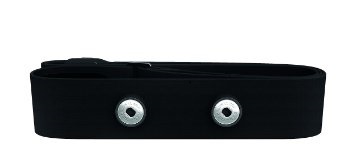
Its (as of August 2015) £10-12 from Amazon so about 1/3rd of the price. So I ordered one - from Wiggle in this case for £12.30 in a M-XXL size. It arrived promptly as always and I went to fit it.

This is where the only problem arose. It's not clear from the photos but in fact around the popper is a rubber collar. I assume that this is to form a water proof seal around the contacts on the transmitter unit. No matter how I tried I could not get the transmitter to fit so I had two choices - return the strap or "modify" it. For £12 I decided that I would trim the rubber collar back so that the transmitter would fit, so carefully, with a new and hence super sharp Stanley blade, trimmed about 2mm off the collar. 

Here are the bits I trimmed off:


The result was that the transmitter then fitted perfectly. Since then I have worn the strap for all rides expect commutes and it has worked faultlessly in every circumstance. It has been absolutely drenched in sweat when I was in the French Alps and never had any issue. This is what I would have expected the Garmin strap to deliver - but in this case Garmin won't get any more of my money for a HR strap.


As a side note I read on a forum that sometimes Garmin straps can be made to work again but cutting a 5mm or so strip out of the strap between the poppers. I have not tried this through!


Sunday, 30 August 2015

Col du Telegraphe and then "The Mighty" Col du Galibier

The biggest climb around Bourg d'Oisins is the Col du Galibier. Given a 10/10 in "the book", its 2646m high with a height gain of 1216m from Valloire. Its 19km long with an average gradient of ~7%. We planned to climb from the north and that route means that its not just a climb of the Galibier but also the Col du Telegraphe as well first. On its own the Telegraphe is a 6/10. The Telegraphe is a 12km climb of 878m (average gradient 7.4%) to an altitude of 1566m.

Given these numbers I was really excited to have a go at this pair of Cols. There were some considerations that meant that I actually planned this ride (other than just the route). Firstly there was the small matter of getting to the foot of the Telegraphe in the town of Saint-Michel-de-Maurienne. The shortest route (due to the landslide) was up to the Glandon and then down the other side, along the valley and park in Saint-Michel-de-Maurienne - the short matter of around 50 miles and 90 minutes driving. Second the weather - or more precisely the temperature. Given my experience climbing the Col de Sarenne I was very concerned about the distance and height gain we'd do if the temperature was as high as it was when I did the Sarenne. However the weather forecast for the Wednesday suggested it would be a relatively cool 25 Deg C so we chose that day, but with an early start from Bourg d'Oisins to get most of the climbing done before it was too hot. 

We drove off and reached Saint-Michel-de-Maurienne without any issues (clear roads all the way), and parked just down from the station (commenting that almost everywhere in France seems to be free parking whereas we'd always pay in the UK). After 10 minutes of getting the bikes and ourselves ready we set off. As the Telegraphe starts less than 1km from the main road, we headed off for 3-4km first in the wrong direction to warm up as much as we could. So we passed the car again and rode through the town and the turned right to climb the Telegraphe.

Here's the route:


The Cols of Telegraphe and Galibier from the North
The Profile
We crossed the river and went under the railway and the climb started - as with all Cols the gradient went from almost 0 straight to ~8%. My son started pulling away almost from the off and I found the first few km hard as I was not properly warmed up. However I was able to stay in the 28tooth at the rear and gradually my heart rate started to drop a little for the same level of effort - and whilst it was not easy it was certainly much easier than it had been in the first week and my confidence grew. I was still conscious that I had a big ride ahead and it was all about pacing and took it steady.

About 1/2 way up I was passing a picnic area and was flagged down - "Francais?" was the question - "non-Anglais" was the answer. The wrong answer it transpired. The issue was that the front wheel of one of the cyclists' bikes (a brand new mid spec Trek) had completely gone out of true. He'd got it "better" with some brute force using the slats of the picnic bench but it was still very bad and he wanted to open the brakes and needed a multi-tool- so I lent him mine. He ended up having to remove the brake pads as well. Once he'd got that far the bike was as readable as it could be and I re-packed my tool and set back up the Col.

It was not a massively hard climb - the road surface was good and the gradient even, so it was a case of pacing carefully anticipating the much bigger climb to come. I reached the top in a time of 1:00:16 - I was very please with that as I'd "lost" about 5 minutes with lending my multi tool - a time of 1 hour put me at around 4800th of over 13000 so pretty good I think. Here's the requisite photo of my bike at the summit:


At the top of the Telegraphe
A quick stop to fill the water bottle I'd emptied and we set off for the Galibier. There's a reasonable and fast descent down to the village of Valloire, and then you follow the one way system round to the climb for the Galibier. The climbing starts in the village in fact and I was in the small front in the village. It then heads out past 1-2 km of ski lodges starting at 19km to go. It was actually steeper than the the overall average gradient for these couple of km and it was hard and tiring. The gradient then eased to a few % to 5-6% for quite a few km. If I was less tired I'd have been able to push on the big ring but I need to use the small and could not get a good cadence going.

As the climb progressed it started to rise at a more consistent gradient and I started to feel better as I got more into a rhythm. It continues like this up to about 10km to the summit - constantly climbing and the landscape getting progressively barren and mountainous. I passed a few cyclist on the way. There was some traffic but not a lot and the road was wide enough to be passed easily.

The 10km point marks the start of the "Big mountain". You pass a small cafe on your left (Plan Lachat) and a few 100 meters further on the road doubles back on itself and the real climbing begins.

It starts with several straight sections zig-zagging backwards and forwards for a few km. Once you are heading generally southwards again it straightens and then curves round following the contours. There is another sharp hairpin and the road now takes a more southwesterly route. It continues in this directions climbing all the while but contouring round the mountain. Its about this point that you can just start to make out the summit and see that there was snow still on the summit. It was also very windy here and the bike was blown a little around in the strong gusts coming of the summit. The gradient seemed to ease slightly here and I was able to drop into 3rd gear (34-26) and press on.

The hairpins stat again about 1.5-1km from the summit. A photographer was here and I later bought one of the photos.


At 1km the choice is to go through the tunnel (Bikes are banned) or ride up to the summit. There's again several switch backs and the gradient rises again. I was hoping to stay in the 34-28 but need to use the 34-30 for the last 500m or so. Finally you crest the summit which is quite a large area surprisingly with a car park and a lot of cyclist standing around the sign. Here's me and my son at the "top".


My son at the top of the Galibier


Me at the top of the Galibier (with my sons thumb!)
Here's a video of the last 9km of the climb (50 minutes long):


Its not actually the highest point - you can clamber a further 20-30m higher - but I was not going to do that in cycling shoes!

I stood around and enjoyed the view:


Looking South from the of the Galibier


Another view looking south from the top of the Galibier


Another view looking south from the top of the Galibier


Looking north from the top of the Galibier (the way we'd come)


Looking north from the top of the Galibier (the way we'd come)


Looking north from the top of the Galibier (the way we'd come)
After 5-10 minutes at the top all that was required was to go down again! We stopped for some lunch in Valliore. I had a very nice pasta dish

Lunch in Valloire
Leaving Valliore meant we had to ascend to the top of the Telegraphe again. It was not too hard a climb but after a lot of climbing already and stopping for lunch I could not quite make it up in the big ring (my son did though). The descent off the Telegraphe was fast although there was no way I could or would live with my son's speed down the mountains.

To Summarise:
  • The Galibier is the highest point that I have stood on earth
  • I climbed a total of 7500ft over 48 miles at an average speed of 12mph
  • 7500ft is the biggest climb I have ever completed on my bike
  • Its the best climb I have ever done and the sense of achievement was tremendous

There's a Strava segment that replicates the TimToo timing points: https://www.strava.com/segments/7474237
Its an "HC" climb - 11.3miles long, average gradient 7% of and height gain of 4044ft. I made it in 1:30:12 and was placed ~2600th of 12800 - excellent I felt.

Awesome!

Wednesday, 5 August 2015

RideLondon 2015


I was lucky enough to get in the RideLondon 2015 event this year through the ballot process.

I wrote about my 2014 ride here: My RideLondon100 - August 2014. Short summary - negatives - dreadful weather and 86 miles only; positives - fastest sportive I had ever ridden - 86 miles in 4:30 at an average speed of 19.1mph

I had really not thought much about this years event other than I was in it - there had been a number of personal issues taking my attention and a 2 week cycling holiday in the French Alps was much higher up my list of priorities. As such I didn't really think about it much until a bout 2 weeks before it was on, and most of that was sorting out the logistics of parking and when I'd go to Excel to collect the rider pack

After the 2014 edition which was shortened due to the weather I was hoping for better weather and to do the whole distance. In the week  before I paid close attention to the forecasts and it looked promising as the week progressed

We drove down the Thursday evening before and I rode into London to the Excel Centre as I had the previous year. It wasn't that busy and the pick up was very slick. I still don't understand why the packs can't be sent out by post - it really means for me (and others who don't live in London) a need to take an extra day's holiday. The cycle show at Excel isn't that great either. I guess its lucky that its only 12 miles or so away from my parents house and I am happy to cycle it. This year after the show I rode straight back as I didn't need to worry about where the Olympic Park was or Surrey Quays as I knew this from last year.


I did the normal sums to work out what time I needed to get up on the Sunday morning in order to have breakfast, load the car, drive to Surrey Quays, unload my bike and then ride to the Olympic Park. It meant a 4am start - needless to say I didn't sleep well and was awake before that. Despite this I didn't have a massive time gap and rolled up in my start slot (Pink, A) at about 5.50am ready for my 6.45 start. Fortunately the weather was mild and the waiting was not too bad. Here's a picture of the wait:


Finally our group was released to the start zone and we moved forward. Here's a video of the start - despite the number of people it was an orderly and smooth start:

RideLondon 2015 Start

There's not really a lot to see but some good riding and smooth pedalling. As a mass start there was no pushing and shoving so fair play


The first real landmark (and I don't mean the streets of London) is Richmond Park. I started my Garmin Virb for the ride through the park:


Richmond Park

I passed Joanna Rowsell in Richmond Park - she can be seen at about 5 minutes 40 seconds and 9 minutes and 45 seconds. At she can be seen having her buttocks caressed - I am hoping by her new husband. Here is the evidence:


I didn't initially think it could be her as she was carrying a huge quantity of "food", but on Twitter I later saw proof:


Joanna Rowsell's RideLondon Prepration
I was quite surprised she needed this much food for 100 miles! The Pearl Izumi kit was also very pink. Beautiful pedalling style of course

Last year Richmond Park was quite a bottle neck especially with the bad weather - but as the video showed it was much more free flowing this year. I don't know if this was related to the weather or my start time but I didn't complain.


After Richmond Park the route is a bit nothing - once you get to the Surrey Hills you come across Newlands Corner and from then on its really just a ride at that point to get down to Leith Hill and Box Hill. Newlands Corner is a gentle and short climb, but as per last year people were walking from the start. However again traffic was lighter and it was an easier climb this year with less pushing and shoving on the right. A fast descent off Newlands Corner then follows and the route works its way towards Leith Hill

I've not ridden Leith Hill before but was keen to tick it off as its #17 in the 100 Greatest Climbs. It was not really well marked where it was or that is was coming up but it became apparent as the road started to narrow, and more usefully there were signs showing "tortoises" to keep to the left and "hares" to the right. I sat on the fence a bit and hung in in the middle as I wasn't sure if I was going to be fast enough. There was some jockeying for position nearer the bottom but it tended to improve as the climb continued. I felt reasonably strong and drifted more to the right, although the overall pace started to drop as we climbed.  I had left my 12-30 tooth cassette on from my France trip and while I didn't need it it made it easy to drop into that gear and I was able to change pace from slow or faster depending in the traffic. As a hill in its own right it was not that great a challenge to a regular cyclist, but I would imagine that for the occasional rider it was far too tough. There were people walking almost from the bottom. My heart rate did get higher than I expected but from the Strava Leith Hill KOM Challenge 2015 I was about 2000th of about 10000 so I was happy with that. Here's a video - not sure why the quality is not as good as I'd expect though.


Leith Hill Video


Following the descent from Leith Hill its then not too far to Dorking and then on to Box Hill. Unlike Leith Hill I had ridden Box Hill before and had a better idea what to expect. We turned off the A24 and started towards the right hand turn that marks the start. It slowed immediately but it seemed only temporary and about 1/2 way up the first straight its started to thin out and I got to the right side of the road. Once round the first hairpin more space appeared on the road and I was able to keep right and move on generally faster than most people. The road is a bit wider than Leith Hill so there was more space available. On the Box Hill KOM Challenge 2015 I was 2750th out of nearly 13000 so again a reasonable pace. Whilst I was on the 34T front ring I was in 3rd or 4th gear on the cassette and able to push on pretty well and gain some places and time. Box Hill is I think over hyped but in the South it is reasonably iconic.

Box Hill Video


After Box Hill its really all about just riding back to London. Its a drag back to through Leatherhead and back through Kingston, then through Wimbledon where again the "Wimbledon Hill" catches people out - this year I was just about able to flog it out on the big ring I am pleased to say. The last "town" is Putney and this was when I was reminded about what closed roads really mean - cycling the wrong way down Putney High Street at over 25mph!
Once through Putney and over the bridge its a short drag before we pull alongside the river to our right - and its only about 5-6 miles to the finish. Last year there was hardly any one on this stretch and it was hard to get a tow but this year as I pulled on there was a small group with a really big chap who was making a big hole in the air - when I could get close enough I could feel the drop in effort required but he was just a spot too fast and despite some valiant efforts I could not keep on the back and gradually dropped back. As I got closer to the Houses of Parliament I was able to pick the a spot of pace up again and got just back on a small group. The almost hairpin at Trafalgar Square comes almost out of nowhere and needs concentration as the road surface is poor. I missed my wife and mother again who had come to watch. However this year unlike last year I sprinted up at 25mph The Mall and gained a few more seconds to the finish.

My wife just manage to get a couple of shots of me passing her heading towards the Admiralty Arch (I'm in the pale blue top to the right of the pictures):


Last 5 miles Video


There's a few hundred meters to cost to a gathering point in order to get to the side of Buckingham Palace and again I was thwarted as the crowd management let pedestrians through so there was some waiting around so I took a few photos.


However once across you get given your medal:


The route:


My official time was 5hrs, 4 minutes and 20 seconds. I was pretty pleased with that. I had had to stop this year for a "comfort break" and I reckoned without that I would have just made under 5 hours. My Garmin and Strava concurred on an average speed of 19.7mph over 99.5 miles, which was much faster than I expected and hoped for.

I use my Garmin to record split times for 5 mile intervals:


Here it can be seen that I was reasonably cautious about pace for the first 30 miles or so, then speed dipped a bit as the roads narrow towards Newlands Corner at about 40 miles and then on to Leith Hill at about 56 miles. This was a much slower region with the narrow roads and the hill itself. I am not quite sure why the pace then dropped further in the run in to and climb of Box Hill, but once over the hill the pace stepped up quite markedly as can be seen and in the last 30 miles the average speed was over 20mph - I was very pleased with this piece of data. Looking at the data in the excellent Veloviewer (so good that I subscribe) I can see how consistent the data is from this sample:


Because the weather was so much better this year, there were many more spectators and the organisers changed the pedestrian routes, it took my wife and mother some time to get to the meet and greet area so I had a chance for a sit down and relax in the sun. We then all had a drink and then headed back to Surrey Quays - me on the bike and them on the train/tube. After loading the car and a quick partial change we went to the nearby Frankie & Benny's for lunch before driving back to Dartford.

So to summarise my ride: excellent weather - ideal conditions in fact, very fast for me and I exceeded my aspirations, I didn't find it to hard, I did the whole route unlike last year. Two weeks in the Alps were excellent preparation and I could probably have found another 10 minutes without blowing up as well. And I have done it now

Would I do it again next year - no I am not going to, I have done it now. Its a good event and closed roads are awesome, but the route will be the same again, and almost certainly there will be even more people doing it next year.

Its not cheap either( its not that expensive) but when you start adding in the parking etc it all adds up. The need to go to Excel to get the rider pack is also an issue I think. And its a very early start and logistics are difficult. I am lucky my parents house is where it is as it makes it more manageable as without that it would be even more expensive.

So I am happy to tick this one as done.

Sunday, 26 July 2015

Col de Sarenne

After a day off the bike (my wife and I went to Grenoble and then the Musee de la Revolution in Vizille) I thought I'd try something a little different - so aimed for the Col de Sarenne - which is not in the "book" - (100 Greatest Climbs of the Tour de France). I plotted out a route that meant I would climb to bend 16 of the Alpe d'Huez and then ride a small road (the D211A) towards the village of Le Freney-d'Oisins, the rejoin the D1091 and ride to the dam at the foot of the "Les Deux Alpes" climb. I'd then cross the dam and start climbing through the village of Mitzoen and then on and up to the Col de Sarenne. Once at the top of the Col I'd drop down and then ride to the Alpe d'Huez and back. It all seemed quite straightforward sitting in the camp site.

Here's the route:


I started with a bit of a warm up and then turned and headed back to the Alpe - as I was only going 5 bends to 16 I just plodded up and turned off at 16 as planned. The change in character from the Alpe climb to the much smaller D211A was significant, and was flat for a mile or so. However it then started to climb shortly after crossing the Sarenne and kept going up for some distance, firstly through pleasant tree lined roads and a few hamlets but a few miles later became a barren alpine road, cut into a sheer cliff on one side and, other than a small wall, a sheer drop on the other, there were even some tunnels.To the right you could look down on the river valley of Bourg d'Oisins from a great height. (Later we'd try and spot the road from the valley below and its almost invisible, unless there's a car moving its almost impossible to spot the road).

Here's some pictures from my Virb:


I took a video of a little of the climb, and I also descended via this route later in the holiday and took a video during the descent as well. These Videos are here:

The ascent:


The descent:


I'd not quite anticipated the level of climbing on this road and took it very steady to keep some energy in reserve. Once at the top the route was rolling for a few km for a steep drop with a number of hairpins to the village of Le Freney-d'Oisins. It was then back onto the D1091 towards the reservoir and dam of the Lac du Chambon. This (bigger) road was a good surface, and because of the landslip further along was basically traffic free. The gradient was gentler as well so the pace went up. There were a few tunnels along this part of the road and the exit of the final tunnel led straight to the dam. Here's a short video:


Immediately across the dam the lakeside road was closed (this affected the 2015 Tour de France route) and I turned left straight to a 10% gradient for a couple of km to the village of Motzoen. This was a really tough climb for some reason - the temperature was rising as well so it was hot. The road continued to climb through Clavans-le-Bas and then Clavans-le-Haut and here we were on the "Route du Col de Sarenne". The heat seemed to build and the gradient was unrelenting. As I went higher I passed the last village/hamlet of Le Perron and here the last of the tress disappeared and the landscape became quite barren. In addition the gradient changed from 6-8% to more like 8-10%. I'd managed to hang in the 34-28 gear as the lowest up to this point but from here I needed to use the 34-30 gear more often.

Because the trees had gone so the temperature rose and I got hotter as the sun heated me up and the gradient stayed high. I was getting through my water quite quickly by now - both to drink and to use some over my head and back to try and keep cooler. I was passed by one other cyclist going up and several going down. The road surface was not great but at the low speed I was climbing this was not a problem - although the descenders were very cautions. I continued to climb but it was incredibly hard work. Eventually I could stat to see what I believed must be the top and I got a lift - up to that point I was thinking that I was going to need to stop and the rate I was getting through water was starting to make me quite concerned that I was going to run out. It took a further 20 minutes or so from seeing the top to reach it and I was extremely grateful. There was almost nothing at the top though - a small sign and what looked like a ski lodge with 2 cyclist sitting outside. I wobbled along 50m or so of gravel track and sat at a bench. A woman came out and after clearly a non-French "Bonjour" from me she realised that I was English - the outcome was a cup of coffee and a slice of apple pie and ice cream, and a jug of water which resulted in full bottles:

Welcome refreshments at the top of the Col de Sarenne
View southwards from the top of the Col de Sarenne
Knackered!
The refreshments were very welcome and I rested for 20 minutes or so, then set off again, turning right to continue along the road. This immediately dropped down with a very poor surface and wound down the valley for a number of km. It then started climbing again - but not at the previous 8-10% level - more like 6-8% again and before I knew it I was entering the ski resort of Alpe d'Huez from the back. A short ride through the village and back on to the descent and I was back at the campsite

I had under estimated the ride for this day. With the climb not being in "the book" to contextualise the difficulty it was a case of take what comes - and it was very hard. I was also concerned about how close I'd come to running out of water and as a result for subsequent rides I stopped and stopped and topped up my bottled whenever I saw an "Eau potable" tap.

Sunday, 5 July 2015

Cycling in the Alps - Alpe d'Huez - Properly

I climbed Alpe d'Huez on the first day of our holiday but turned right at round corner 4 so whilst I got to the top I did not follow the classic route ("Itiniere De Tour"). So I did it again and made the effort to get to the proper TdF finish rather than the top of the climb in the village.

Despite having climbed it once before and therefore knowing the route better I was slower everywhere that the first time I had climbed it - how could that be?

Here's the link: https://www.strava.com/activities/336010344


Here's me (after the 2nd attempt) at the top of Alpe d'Huez:


Wednesday, 1 July 2015

Col de Croix de Fer and Glandon

We're on holiday in the French Alps and on the first day tackled Col d'Ornon and the Alpe d'Huez. 

We were then equally ambitious and rode up to the Col de Croix de Fer and Col de Glandon from Bourg d'Oisons on the second day. I think we were a little over-optimistic and were basing everything on the previous days climbs. It turned out to be a monstrous climb - for me over 2 hours of climbing: https://www.strava.com/activities/335403446

The Route (there and back)

We started with a necessary warm up ride which was from the camp site, along the valley road (D1091) to the village of Allencon which marks the start of the climb. This is 2 zig zags up the face of a dam. We then turned left and rode along the side of the reservoir with a slight climb to the Musée EDF Hydrélec near Vaujany. This is the end of any respite though and after a few further hundred meters the road crosses a river bridge and the incline starts - straight up at 8-9%. The roads continues to meander on the left side of a valley, the gradient varying slightly but never dropping below 7% and often rising to 10%. This went on for some time and it took a couple of km to get into a rhythm. I needed the 30t on the rear again and was able to occasionally  use the 28t, and passed (slowly) a few other cyclists climbing the same route.

There was a tiny Hamlet (Aricol) after a few miles and then a slightly larger village - Le Rivier d'Allemenot. This did have a Eau Potable tap for those that needed water. About 1km later the road starts on a slight descent that suddenly turns into a 12% descent with 4 very sharp hairpin bends. This was not what I wanted to see as not only was there a descent but I could see the height that needed to be regained immediately afterwards. I rolled down the bends knowing that I was going to pay for it and after just a couple of minutes was back into the climb. However in this case it wasn't 7-8% but 10-12% for a good km. After the drop down this was really hard to get back into the rhythm again and I just had to slog it out. I really needed the 30t here. The climb then plateaued slightly before a left-right kink over another bridge and a climb back at the ore normal 7-8%.

At the next hairpin a Movistar liveried van was quite along way over the centre of the road but a few moments later I saw Nairo Quintana descending with a team mate. Probably a recce ride for this years Tour. I captured him on my Garmin Virb and here's a link:


Look at about 50 seconds - blink and you'll miss him! 

Here's a still:


After this the trees thinned out a bit and the climb continued. There were a few more hairpins and then a straighter section - all still at 7-8%. Gradually I could see the second dam ahead - the "Lac du Grand Maison" that feeds the  hydro-electric dam at Allencon. To get to the height of the dam and skirt the lake were another couple of hairpins and then then road skirted the valley with the lake to the right, and for the first time the gradient lessened to 4-6% - I was still in the 34t at the front but in the middle of the cassette at the rear - however I was passed by two people riding on the big ring! A little further on and the road lost some height - perhaps 50-100m over 1-2km so it was good to descend again and have a slight rest - although painful knowing I'd need to regain it again. The terrain here was also very open - short grass, rocky valley sides. The gradient eased up again to 7-8% again and it was a case of slogging it out. After a few more km I could see a building ahead and guessed it was the split between the Glandon and Croix de Fer summits. This was the case when I reached it and then saw the sign for Croix de Fer to 2.5km further on - not a great feeling as it seemed I should be there by now. These last few km were hard knowing there I was nearly there but not quite.

However finally I got to the top. My son was sitting at a table in front of the cafe having had an ice cream and coffee. It was great to reach the top - and have a coffee and ice cream. The views were fantastic, air clear and the sky blue.  We took some obligatory photos and then we rode down to the junction and back up to the summit of the Glandon

Here's some pictures:


My Son


Selfie


Looking North


The proof


The actual Croix de Fer


At the top of Col de Glandon
After this we rode back down again. Just like the day before the experience of descending for 20-30 minutes at a time is not something that I've done before, and with a bit more practice this was a better descent. The steep descent on the way up hurt as much on the way back though!